
As part of our research initiative, we are building and maintaining one of the largest databases of organizations and institutes that serve Latino communities (figure 1). This infrastructure includes:
1) Latino-serving non-profit organizations;
2) Research institutions;
3) Foundations and scholarship organizations; and
4) Law schools and clinics (currently this map only includes California law schools and clinics).
For each organization we entered into the database (Figure 2), we included geospatial indicators, relevant contact information, details on leadership of the organization, and website information (Figure 2).

Figure 1. Latino-serving non-profit organizations across the U.S. To date, we have input over 200 non-profit organizations into our GIS database.
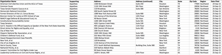
Figure 2. Sample of GIS database.
We classified these organizations/institutions by type, area of focus, services provided, and location. Utilizing the program ArcGIS, we made an interactive map with descriptions and contact information that can be easily navigated (see Figure 3). ArcGIS proved to be an extremely useful tool, as it allowed us to spatially organize our data and isolate important trends. It is our hope that, as a living document, individuals and organizations can suggest additions to the map so that it is truly a collaborative community effort.

Figure 3. Interactive GIS map, showing details of the Los Angeles area.
